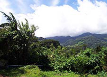
Boquete is a small town tucked into the green mountain highlands of Panama, in western-most Chiriquí Province, about 60 km. from the border with Costa Rica. Because of its altitude, some 1,200 metres above sea level, its climate is refreshingly cooler than that of the lowlands. Its scenic location, temperature, and natural environment make it extremely popular with Panamanians, and with tourists from all over the world.
History
In Spanish, the word Boquete means 'gap or opening'. It was through this gap that curious gold seekers trekked, looking for a cheaper and quicker way to the Pacific. Farmers began settling the region near the end of the 19th Century. By the early 20th century, several villages had been populated: Lino, Quiel, Bajo Mono, Los Naranjos, and Bajo Boquete, which now is the districts' town center.
Boquete was created on April 11, 1911. The head of the district was initially Lino, but it was moved soon after to Bajo Boquete. For many years, the district had three "corregimientos": Bajo Boquete, Caldera and Palmira. In 1998, the "corregimientos" of Alto Boquete, Jaramillo, and Los Naranjos were created.
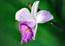
In addition to tourism, its main industry remains agriculture, especially the growing of coffee beans.
Nature
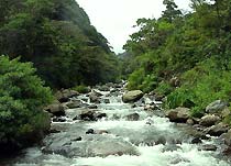
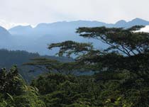
Some of its landmarks include nearby Volcán Barú, a dormant volcano and, at 3,475 meters, the tallest point of land in Panama. Hikers enjoy a relatively easy hike up and over the volcano, along the Sendero de los Quetzales, which runs from Boquete up to Cerro Punta and Volcan, on the other side of the volcano. Boquete is well known for its coffee, judged to be among the finest in the world. The Caldera River runs through the town, a river that has shaped much of its form.